Follow us on Facebook @FHofDW
The History of St. George’s Road
High Street to West Street
St Georges Road from High Street to West Street was, at various times, called Chapel Row, Chapel Place, St. George’s Place and finally, as today, St. George’s Road. In some documents, up until the 1820s, it is also called Spring Gardens which may suggest that this was its original name before the Chapel of St. George’s was built.
In the beginning
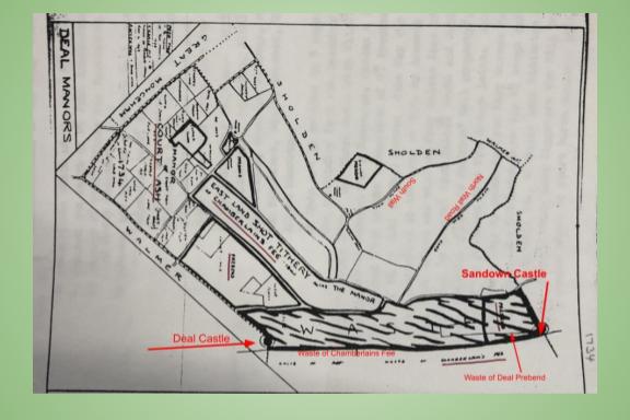
St. George’s Road was once part of Chamberlain’s Fee, one of the Deal Manors owned by the See of the Archbishop of Canterbury. It consisted of two pieces of land named Eastlands Shot and the Gosse.
Eastlands Shot extended from Manor Road between Mill Road and St. Leonards Road down to Albert Road and Western Road to Ark lane, then from Mill Hill to Wellington Road.
The Gosse laid roughly from today’s West Street to High Street and from St. George’s Road to Alfred Square so this included the land on which St. George’s Church and St. Georges Road sits today.
Deal Manors
According to a transcribed summary of the ‘Frankpledge and Court Baron’ for the Manor of Chamberlains Fee, held in October 1665, Richard Bridger had purchased 3 acres of land lying in the Gosse, from ‘John Pretyman Esq. and Margaret his wife’. Other documents, held by Lambeth Palace, tell us that Richard was a brewer and that he purchased further leases in Deal.
The Frankpledge and Court Baron, held in October 1669 says that Richard Bridger had died ‘seised of’, that is in legal possession of, ‘1 acre 3 Roods and 20 perches of land which he purchased from Isaac Gogar and of 3 acres of land called the Gosse which he purchased from the heirs of Matthew Mennes and 1 acre in the Gosse purchased of Richard Watts’. This now passed to his son and heir Peter.
So, by the mid to late 1600s, the Bridger’s were one of a handful of families in Deal, holding land from the Archbishop of Canterbury.
When Peter Bridger inherited his father’s holdings the castles of Sandown, Deal and Walmer were just over a hundred years old. The three main roadways laid out between them, of Beach, Middle and Lower (now High) Streets were lined with not only shops and houses but also barns and plots of land for animals and small holdings growing food, not just for local consumption but also for the naval and merchant shipping anchored in the Downs.
The growth of European maritime exploration, trade and naval shipping at this time, coupled with the safe anchorage of the Downs, fuelled the town’s growth.
However, the fast expanding town was not yet a Borough and still thirty years away from its independence from Sandwich. At the time this meant that the local taxes were set and paid to Sandwich. If laws were broken a magistrate from Sandwich was relied upon to rule upon and dispense punishment. A long-standing law “… proved a great injury …” to the townsfolk who had to travel to a Market Town to buy corn and provisions. Sandwich was the nearest market town and the ten mile round journey, not only affected ordinary households but the growing number of businesses in the town especially those wanting to trade with the ships in the Downs. This was one of the reasons put forward for independence from Sandwich as
“…sometimes may be seen three or four hundred ships of all sizes at anchor, which have been supplied with fresh provisions and necessaries from us; but now corn, flour, etc, must be bought in a market … Unless we are made a Corporate and Market town we shall not be able to supply … the wants of the shipping which are sometimes very great. This will be a great detriment to the public trade of the country, to our East India merchants’ ships and other trading vessels which sometimes lie in the Downs a month or more for a fair wind…”
On 13 October 1699 His Majesty King William 111 granted Deal its Charter of Incorporation and in doing so it gave the town the freedom and powers to annually, on August 1st, elect a Mayor and other offices; to enrol freemen; to provide a gaol or prison; to hold a market every Tuesday and Saturday; a cattle and goods fair, held over two days, twice a year; to hold Pie-powder Courts and to make laws, bye-laws with penalties as and when necessary. It also gave the right to sell and buy land.
In an age when church going was expected of everyone, the latter became important when easy access to a place of worship became difficult or inconvenient for the fast expanding ‘Lower Deal.’ The parish church of St. Leonards was just over a mile away, at ‘Upper Deal’ and was becoming too small for all its parishioners and the visiting navy and seamen. So, now being able to make its own decisions including buying land, it was decided to build a Chapel of Ease. Peter Bridger offered, in February 1706, to sell the lease on a plot of land in the Gosse, on which to build the Chapel. In May 1706 the approval of the Archbishop of Canterbury, as the owner of the Gosse, was sought.
Peter Bridger was either approached or offered to sell a piece of land on which to build a Chapel of Ease and for a burial ground “… for and in consideration of the Summe of eighty pounds of lawful money of England to him in hand paid by the said Mayor Jurats and Commonalty…”
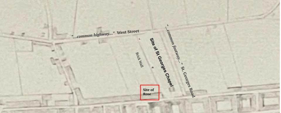
The deeds that were signed on June 18th 1707 make interesting reading as it gives a small insight into the rural nature of the town at the time. The “… piece or parcel of ground or land…” was at the time, if not physically lived on by a man named William Bridges it was certainly being used by him. It is described as adjoining Lower Street with a house,owned by Peter Bridger, as well as a brickwalled barn on one side, where today’s Rose Inn is situated.
Then, as now, bordering the ‘parcel of land’ was a “…common highway…”, West Street and a “…common footway…”, St. Georges Road.
Peter Bridger sold the lease on the understanding that he and his heirs could, whenever required, have free “…access with workmen or others to repair and maintain the… brickwalled barne, house and buildings… and bring and lay there on bricks timber lime mortar straw and other Necessarious for the making and doing of such repairs…”
Map of area owned by Peter Bridger
We don’t know what the extent of Peter Bridger’s land and property holdings were in Deal when he died in Cornhill London, in 1709, and there is no surviving will to help us.
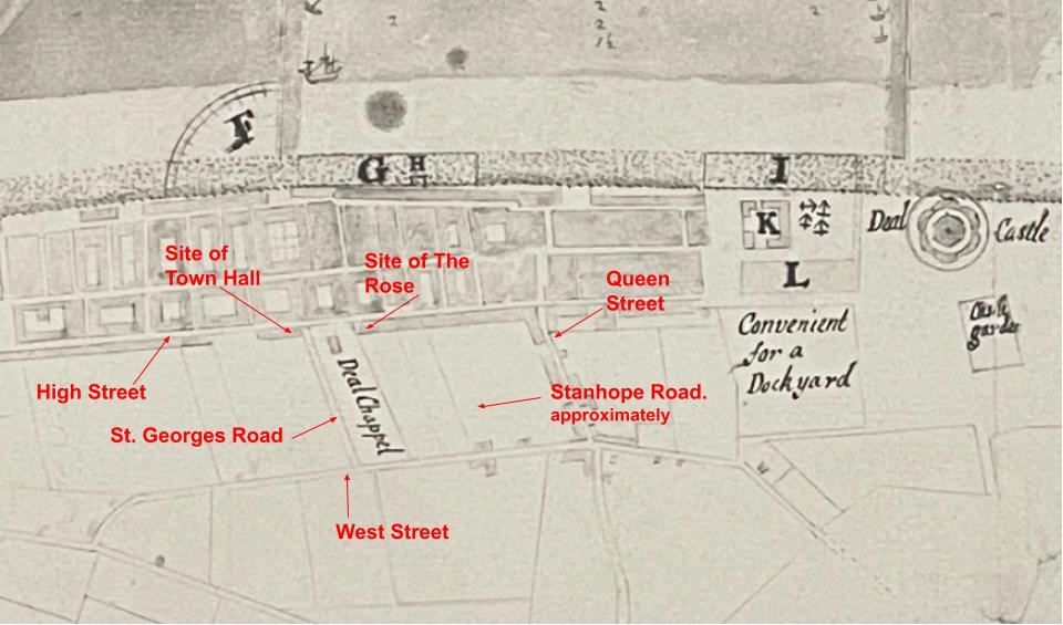
From his father’s will we know that Peter inherited all his land holdings including those 4 acres in the Gosse. Assuming that those 4 acres were contiguous, it could mean that he owned the whole of the St. Georges Road up to and including today’s Town Hall; the land on which St. George’s Church was built; the plot where The Rose now sits and possibly beyond it to what is now Stanhope Road.
1749 map for the proposed harbour for Deal PL/33
How reliable this 1749 map, for the proposed harbour for Deal, is, is difficult to say but St Georges Chapel can clearly be seen with buildings on Lower (High) Street spreading out either side of it. But there are no structures on St Georges Road. Properties on Queen Street, then known as Five Bells Lane, are there.
According to Town Hall records in 1739 a gentleman from Sandwich, named Richard Maundy, sold a property to Thomas Kipps, a tobacco pipemaker from Thanet. Commonly called the Bear Pump, it consisted of a tenement with outhouses, yard, garden and ground with passages and waterways near to the Chapel. The property abutted the Kings Highway to the East (High Street), and to lands once belonging to Peter Bridger to the West, North and South.
So this supports the theory that Peter Bridger owned the area that was to become St. Georges Road. Plus further records show that, in 1711, Mary Brouckner, Peter’s daughter and her husband Thomas sold a parcel of land in St. George’s Road on which the houses today numbered 16, 18 and 20 now sit. Suggesting that she may have inherited at least that part of St. George’s Road from her father.